If the thing is feasible, the first to do it ought to be an Englishman
Around the World in 80 Days – Jules Verne
I turn 61 today.
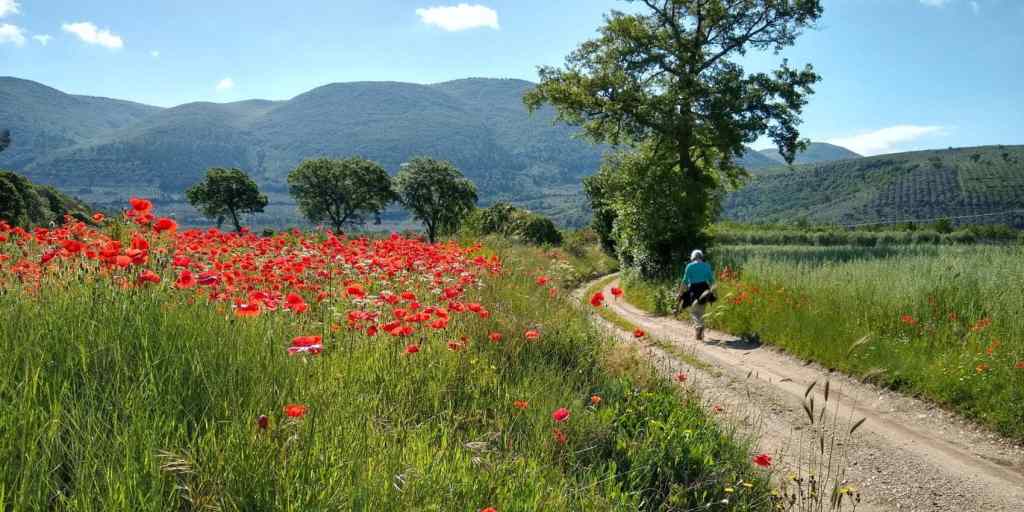
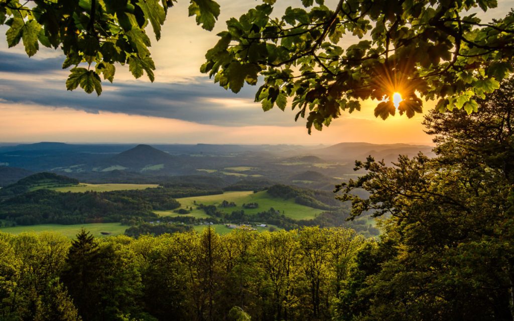
The sunflowers in the field below our house have finally been harvested and although temperatures are still in the low 20s, the clocks have been put back and the evenings are drawing in.
So, as well as celebrating with family and friends today before the winter sets in its time for a bit of self indulgent pipe dreaming in my final blog for 2024 from sunny south west France!

Readers of this blog with long memories may remember that this time last year I published a blog entitled ‘Life Begins at 60 – LEJOG 2024’. Well may you ask “So what happened?” Sadly, for logistical reasons, LEJOG 2024 had to be shelved. Instead I had to content myself with walking a number of pilgrim routes in France spread over the space of a little over a month. In the process I’ve shed a few pounds, walked around 1,300km, explored a lot of remote and beautiful parts of France and had some fascinating encounters with strangers.

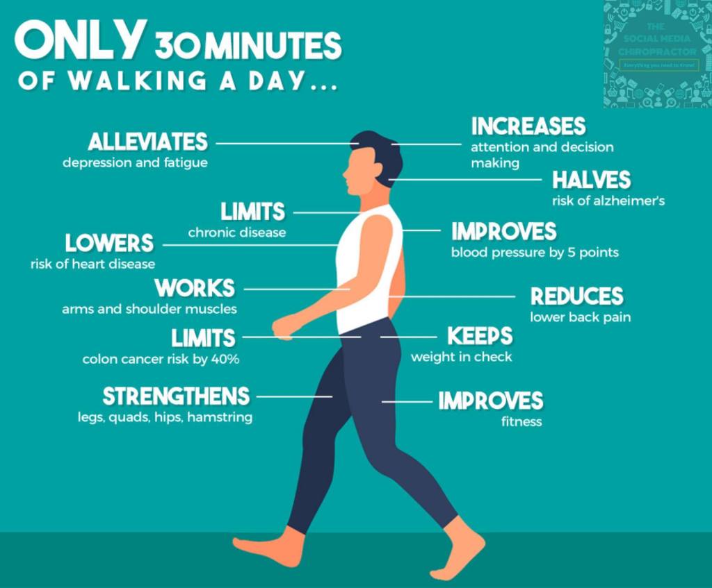
Although I am now very much a sexagenarian (and well on the road to becoming an OAP!), I still feel pretty healthy and young at heart. They say walking 30 minutes a day is good for the mind and the body. By extension therefore, walking up to 11 hours a day for up to a month at a time, should put one well on the way to discovering the secret of eternal youth!
Who knows how many years of long distance walking I’ve got left in my knees and legs. Another 10 -15 years if I’m lucky, maintain a relatively healthy lifestyle and continue to cut down on the camembert and red wine! The big question, of course, is what next?
Well, after a bit of research, I’ve come up with a birthday bucket list of 30 long distance walks (of which 8 follow pilgrim routes) I’d like to complete before I hang up my boots and take up more sedentary pursuits like dominoes or cribbage. 9 of these are in France, 6 are in the UK, 5 are in Eastern Europe (a region I’ve never visited) and the rest are split between Scandinavia, Portugal, Italy and Asia. Its highly unlikely that I’ll do half of them but you never know.
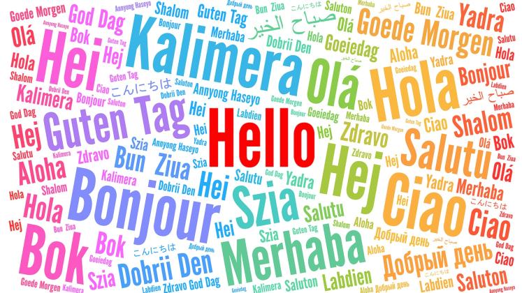
As well as the walking itself, one of the other things I’m most looking forward to, is the opportunity to try and acquire a smattering of as many languages as I can. So besides French, I’m hoping to pick up some Italian, Portuguese,Spanish, Norwegian,Swedish, Polish, Hungarian, Bulgarian, Romanian, Croatian, Czech, Slovenian,Albanian,Welsh and Dzongkha, (the national language of Bhutan) over the next few years!
Why bother learning new languages? Well, apart from the fact that I enjoy it and it adds immensely to the opportunity to communicate and converse with the people you encounter on long distance walks, studies have found that learning a second language helps reduce the risk of dementia! In May 2020, three Canadian researchers from Toronto published a study entitled “Does Bilingualism Protect Against Dementia? A Meta-analysis.” The team investigated whether learning a second language delays the onset of Alzheimer’s disease and found that it did!
Anyway now its time for a bit of birthday pipe dreaming.
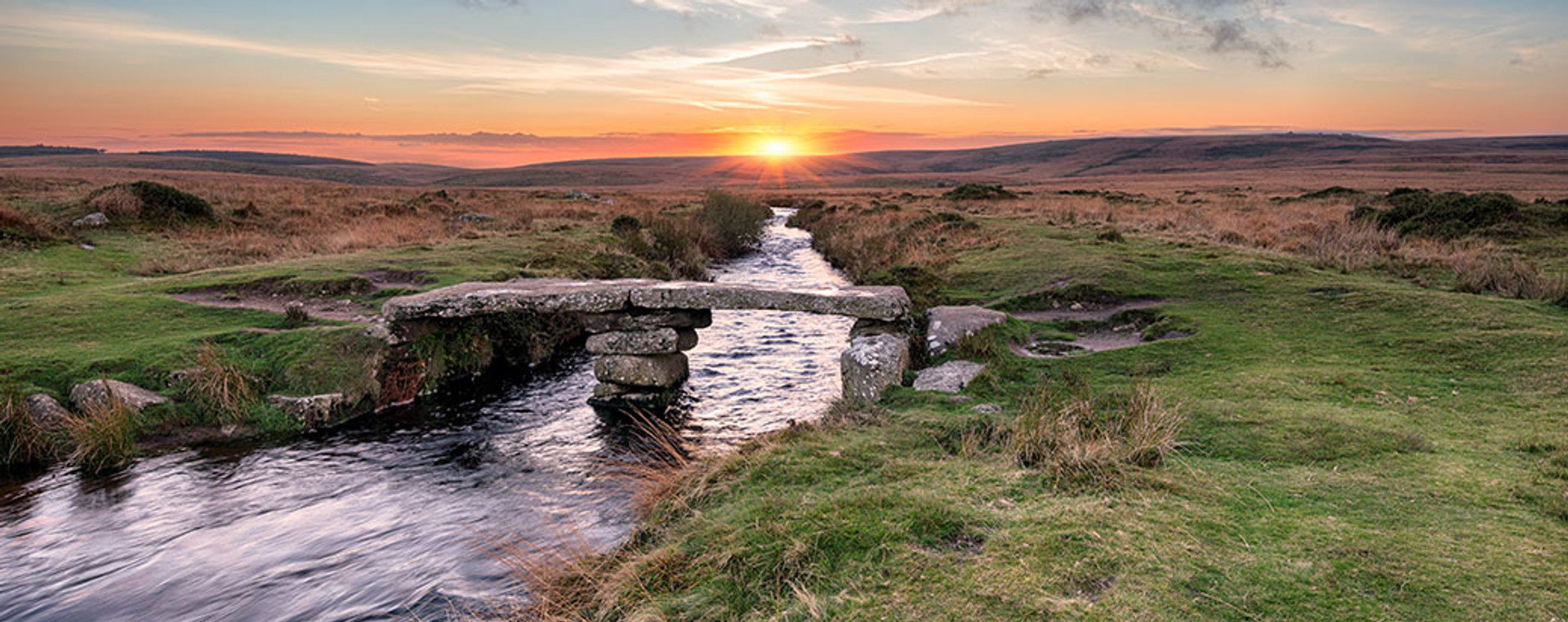
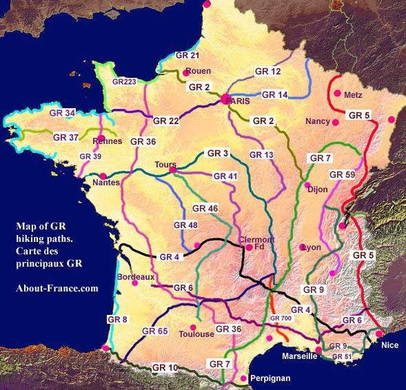
Long distance footpaths in France
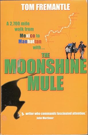
The bucket list of long distance walks that follows may seem a bit extreme and slightly bonkers. But it pales into insignificance with the feat of endurance undertaken by a family acquaintance (Tom Fremantle aka Lord Cottesloe) who walked 11,000 miles/17,600 km around the world from 2018-2023. In the process he traversed the length of America and Europe, a swathe of the Middle East including Turkey, Lebanon, Jordan, Syria (the only country where he needed four wheels instead of two feet), Israel and the West Bank, India, Indonesia (plus Borneo), Australia, New Zealand and Iceland!
https://www.thegreatoutdoorsmag.com/news/what-i-learned-from-walking-around-the-world/

It’s when I read the biographies of people like Tom Fremantle (https://tomsworldwalk.com/tom-fremantle-story/) that I realise what a relatively unadventurous and sedentary life I’ve led. Going off on a two week walk in France hardly compares to canoeing down the Niger in the footsteps of Mungo Park, walking 2,700 miles from Mexico to Manhattan with a mule or walking around the world!

So, without further ado, here is my bucket list of 30 long distance walks some of which I hope to complete in the future, ranked from the shortest to the longest. If possible I’d still like to attempt walking LEJOG (Land’s End to John O’Groats), although realistically it will likely have to be split up into a number of separate walks, as indeed will any of the walks listed below which are over 750km.
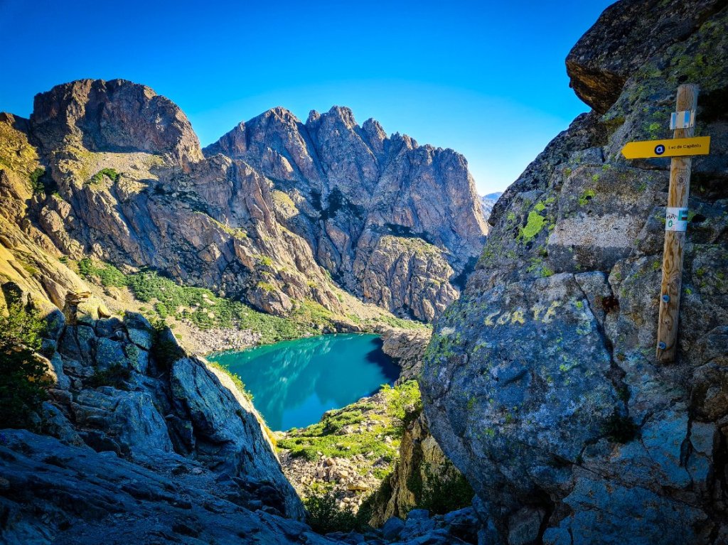
1. The Spine of Corsica GR20 (France) – 180km

The GR20 is the shortest walk on my bucket list but probably the most challenging – the Mount Everest of long distance walks.
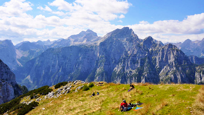
It runs 180km/125-mile down the spine of Corsica between Calenzana and Conca. Its not so much the distance as the elevations that are the challenge: 12,700 metres up and down mountains that do not provide much relief. It’s less a walk, more a 10 to 15-day challenge of body mobility. During the first half in particular,you apparently have to crawl, clamber, slide and slither over rocks of all types: half-melted bowls, huge flat boulders, rods and ingots of grey and pink. Tiny foot holds are the sole protection from endless falls. Everyone calls it the hardest trek in Europe; they have a point.
Throw into the mix the fact that accommodation options are restricted to a handful of mountain refuges with limited capacity which get booked up months in advance and the fact that most walkers have to carry camping equipment and food with them over arduous terrain and you get a sense of the awesome challenge that is the GR20! You’d have to be a confirmed masochist or slightly mad to contemplate walking it….
2. Tour of the lakes and volcanoes of the Auvergne GR30 (France) – 200km
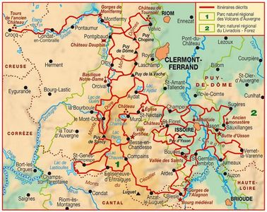
The GR30 connects a dozen lakes and volcanoes in the Auvergne. The walk comprises a 194 km loop around the Puy de Sancy, the highest point of the Massif Central. The trail crosses the five main massifs and plateaus of the Auvergne Volcanoes Regional Natural Park: the Chaîne des Puys, the Monts Doré, the Cantal massif, the Artense and Cézallier.
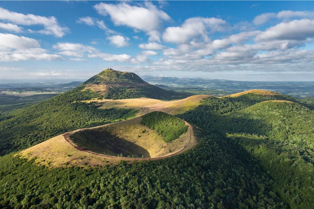
So why bother to hike the GR30? In a word – volcanoes or “puys” as they are known locally. Auvergne boasts a remarkable collection of 450 volcanoes which include the 80 volcanoes of the Chaîne des Puys, also known as Monts Dôme. These volcanoes, considered the “youngest” in Auvergne, range in age from 70,000BC to 7,600BC, with most of their activity occurring between 45,000BC and 30,000BC. Characterized by the classic conical shape associated with volcanoes, they experienced only one relatively brief and recent eruption.
At 1465m the Puy-de-Dome is the tallest volcano in the Chaîne des Puys, while the Puy de Sancy, at 1886m is the tallest in the Massif Central.
Are they likely to erupt any time soon? In recent years there has been much debate on this subject amongst geologists and vulcanologists but the current consensus is that it is extremely unlikely. Phew!
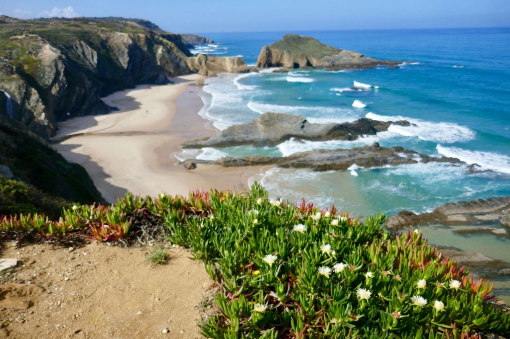
3. The Fisherman’s Trail (Portugal)- 230km
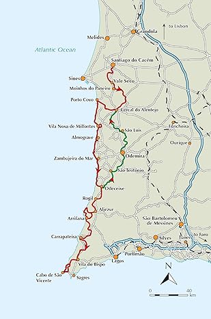
I’ve never been on a long distance walk in Portugal but there are a couple of trails that I have got my eye on, including The Fisherman’s Trail.
Widely considered one of the most stunning coastal trails in the world, the Fisherman’s Trail or Rota Vicentina is a hiking trail that stretches over 226 km/140 miles along the breathtaking Atlantic coastline in the Southwest of Portugal – from São Torpes in the Alentejo region to Lagos on the south coast of the Algarve.
The landscape of the Fisherman’s Trail is spectacular with the path overlooking the Atlantic whose fierce waves have shaped the gnarled coastline for millions of years. When you are not gazing at storks soaring above your head on the shoreline updraft or their impressive nests on top of limestone sea stacks your eyes are drawn south to the endless line of cliffs and waves which give this area an ends of the earth feel. The trail which runs along the edge of mainland Europe is full of secluded coves, and beaches with broad expanses of golden sand. It’s not hard to see why the route is so popular with walkers!
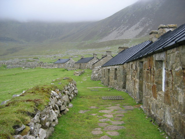
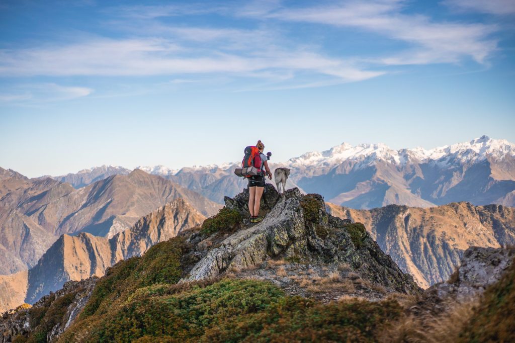
4. The Hebridean Way (UK) – 252km
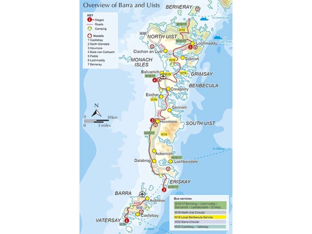
The Outer Hebrides has some of the finest walking in Europe. Nowhere else offers such a rich combination of attractions: stunning beaches, abundant wildlife, turquoise seascapes, flower rich machair, imposing mountains, outstanding archaeology and, of course, the islands’ unique Gaelic culture.
The Hebridean Way walking offers keen hikers a unique opportunity to walk the length of this spectacular archipelago. Over the course of 156 miles (252km) the route traverses 10 islands, crosses 6 causeways and includes two stunning ferry journeys.
It is a route of astonishing variety – one day you may be walking on an exquisite deserted beach, with silver shell sand stretching far into the distance.The next you may find yourself amongst wild mountains, wandering past remote freshwater lochs as eagles soar overhead.
I walked a lot of this Trail in 1988 before the Hebridean Trail officially existed but I’d like to do it again, this time ending up in Eriskay, Barra and Vatersay rather than Skye. It would be fun to revisit the standing stones of Callanish, hike up Eaval on South Uist and revisit the remote settlement of Rhenigidale on Lewis by the iconic Postman’s Path.
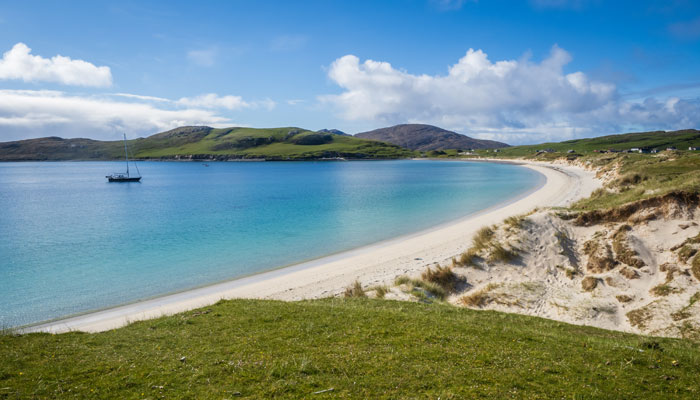
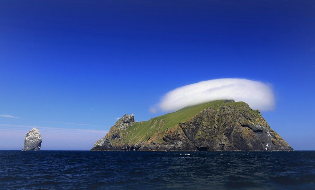
St Kilda then and now
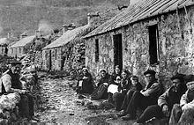
One place that I’d definitely like to add to the itinerary would be a trip to Saint Kilda. Its somewhere I’ve wanted to visit for over 35 years. Its a UNESCO heritage site and was home to a community of 200 islanders who lived there for thousands of years on a diet of seagulls and puffins before their population dwindled during the 20th century and the last 36 remaining islanders were removed to the Scottish mainland on the 29th August 1930.
Guidebooks suggest that the Hebridean Trail is walkable in 10-12 days which means that I could easily combine it with walking the Coast to Coast Path or alternatively, The Cape Wrath Trail. Two walks for the price of one!
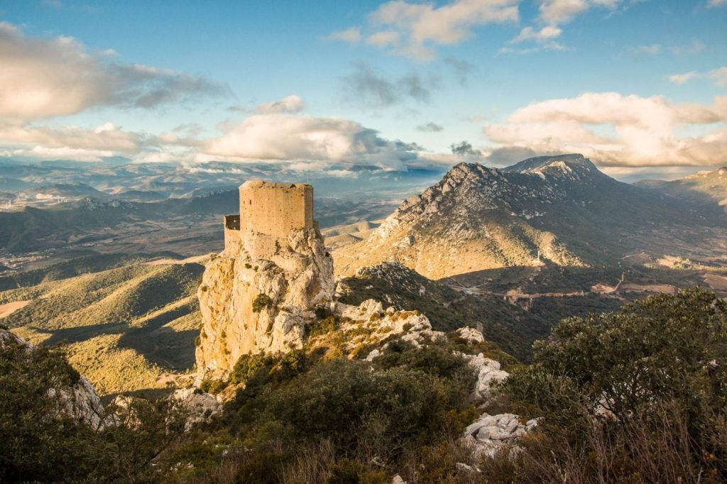
5. The Cathar Trail GR367 (France) – 260km
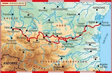
This 260km Cathar Trail runs through the foothills of the Pyrenees in the Languedoc region of southern France stretching from the Mediterranean to Foix. Highlights of the Cathar Way include the ‘castles in the sky’ like Queribus, Peyrepertuse and Montsegur, all of which are linked to the Cathar ‘heresy’, which was brutally suppressed in the thirteenth century.
So who exactly were the Cathars and why is their a path named after them in the south west of France? Well Cathars or Albigensians (who originated near the town of Albi in south west France) . were a group of nonviolent Christians accused of being heretics by the Catholic Church. They became the target of the only Crusade in Europe (in 1209) At their peak at the beginning of the 13th century they numbered about 17,000 and occupied the Languedoc region of southern France that extended from the Pyrenees to the Rhone Delta.
Its not hard to see why the Cathars were such a thorn in the side of the Catholic church, became the target of a crusade, and a programme of persecution which led to them being entirely wiped out by the early 14th century. They attacked the Catholic Church as intrinsically corrupt and morally misguided and an instrument of Satan. They denied the sacraments and allowed women to become priests and administer the last rites. They didn’t believe in marriage or baptism at birth and the only prayer they uttered was the Lord’s Prayer which they recited up to 40 times.
Cathar theology was based upon Manichaean dualism which divided life into good or evil, light or dark, love and hate. Cathars believed that the Old Testament God Jehovah was actually Satan in disguise. They believed that Christ would have never have adopted a human body and thus the body and flesh of Christ never existed and Catholic rituals were fake!
The Papacy threw their weight behind exterminating the Cathars. The Dominican Order was founded in 1205 in order to combat the Cathar heresy. and conduct a programme of inquisition and persecution. A crusades were launched against the Cathars in 1209. An inquisition against the Cathars was launched in 1233. Montségur, a ruined castle on a white limestone cliff in the Pyrenees bacame the last stronghold of the Cathars. After withstanding a siege in 1241, the castle was finally taken in 1244 and 200 chained prisoners from the castle were led to a meadow where they were placed on a pyre and burned alive. The few remaining members of the sect hid in caves and the forest. The inquisition burned any of those found and the last recorded Cathar was burned at the stake in 1321.
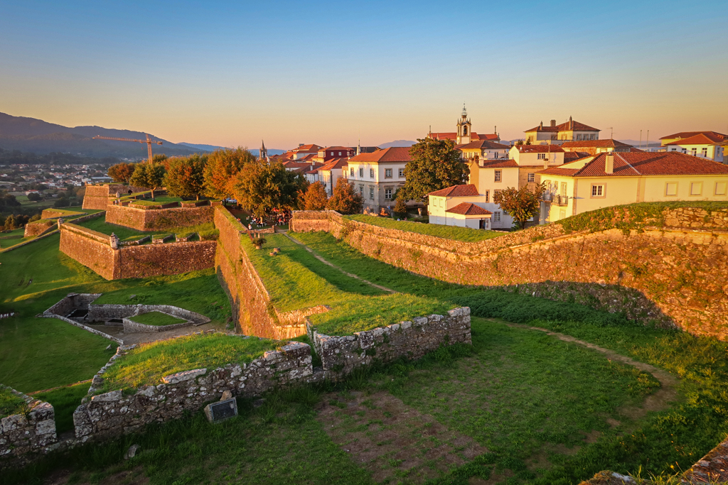
6. The Portuguese Camino (Portugal) – 260km
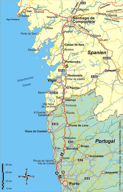
The Camino Portugués, or Portuguese Camino, is a pilgrim route which offers a scenic, rural alternative to the much busier Camino Frances. Portuguese pilgrims have been making the journey to Santiago since the mid-12th century. You can start the Portuguese Camino in either Lisbon or Porto. The latter is an increasingly popular option thanks to its shorter length – 260km from the starting point near Porto, compared to 628 km from Lisbon. From Porto, there are two options to walk to Santiago: the Caminho da Coasta (Coastal Way) or the Caminho Central (Central Way, or Inland Path).
If I ever get to walk the Portuguese Camino I would opt for the route which heads north along the Atlantic coast, partly due to the availability of delicious seafood as well as the opportunities to stay in quaint fishing villages and stop for swims at the many sandy beaches along the way.
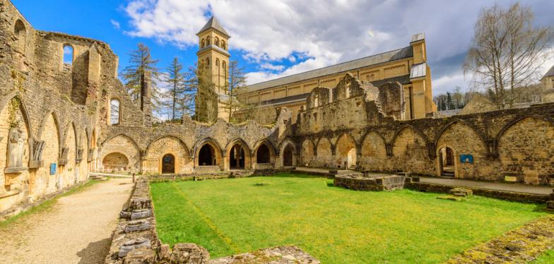
7. The Trappist Abbeys Way (Belgium) – 289km
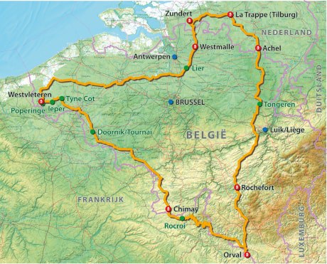
This looks to be the easiest walk on my bucket list – a gentle 289km stroll between three of Belgium’s Trappist Abbeys (Chimay, Rochefort and Orval) which also happen to specialise in beer making!
Monasteries were the first places in the world where beer was produced on a large-scale. They took on this role at the time of the fall of the Roman Empire and the spread of Christianity, when beer became an essential food – not just a drink – for the sustenance of religious communities, especially at a time when its consumption was preferable to that of water, which was often unhealthy. The monks made beer for their own daily consumption, but the surplus production was destined to pilgrims, the poor and possible buyers.
Trappists are a religious order (Order of Cistercians of the Strict Observance) that branched off from the Cistercians. The term ‘Trappist’ came from a French abbey in Normandy called La Trappe, where the order was founded. The monks and nuns that follow the order are required to be self sufficient. This means they produce everything they consume. Earlier, the monks drank just water, but an 1836 reform allowed them to consume local alcoholic drinks, which led them to wine.

Hostility towards the Cistercian Order during the French Revolution resulted in the La Trappe abbey shutting down and its Trappist monks seeking refuge in Belgium and other neighbouring countries. In Belgium, they made Westmalle, Antwerp, and some parts of Flanders their settlements. Here, the wine-drinking French monks took to the local beers. And since they were required to produce what they consumed, they began brewing what we now call Trappist beers. Today, six of those original breweries continue to operate in Belgium, including the abbeys of Chimay, Rochefort and Orval.
There are only ten Trappist monasteries in the world which brew beer and five of them are in Belgium. Incidentally there is one in the UK – Mount St Bernard Abbey in Leicestershire! To qualify as Trappist, the brewery must be physically located within the religious facility, The beer production must be carried out by the monks, or at least be supervised by them and The beer must not be produced to make a profit, so all proceeds from its sale must be used to support the religious community or donated to charity.
Go on a walk, drink beer and help a charity – it sounds like a brilliant idea!
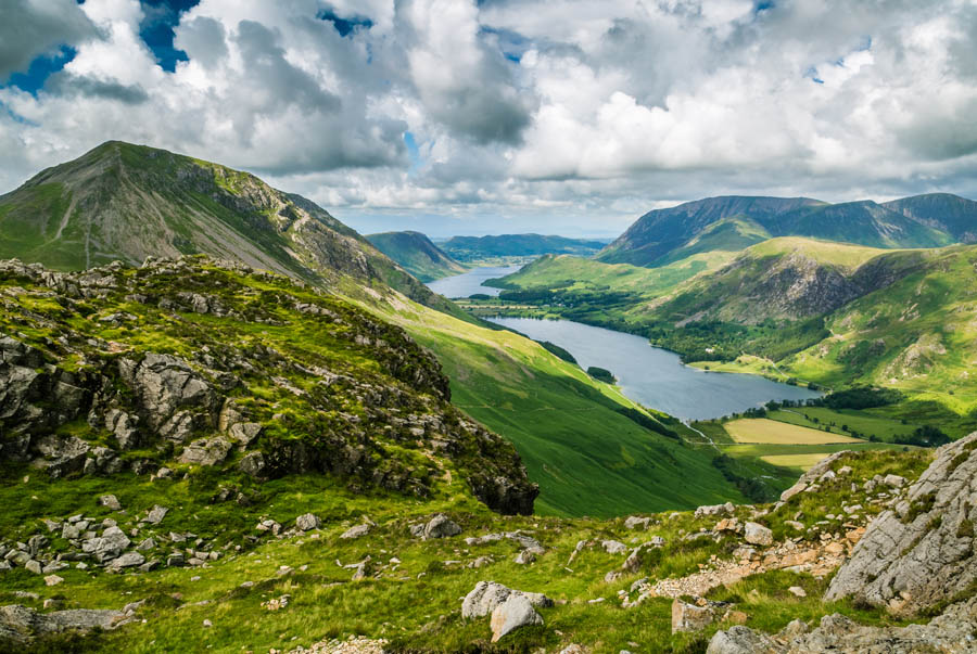
8. The Coast to Coast Path (UK)- 317km
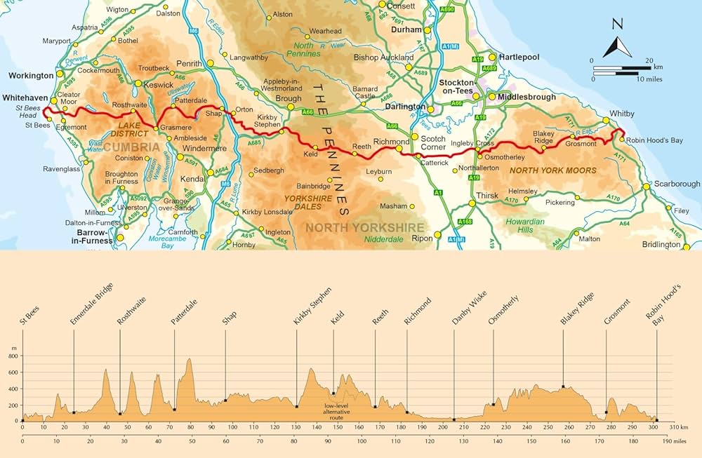
This would be a great follow up to the Hadrian’s Wall Path which I walked in 1986 over an August Bank Holiday weekend. It should be easily walkable at a fairly leisurely pace in a fortnight. Perhaps its one to keep in my locker until the time when my legs start to go!
The varied landscapes that you encounter on this journey are truly epic, from windswept crags and fells of the Lake District to the upland tarns and waterfalls of the moors and dales and of course Sea cliffs at St Bees. The walk meanders 317km/192 miles from St Bees in Cumbria to Robin Hood’s Bay near Whitby, traversing the Lake District, the Yorkshire Dales, the North York Moors and all manner of peaty bogs, rock-strewn hills, rivers, quarries, meadows, trails, tracks, farms and derelict mines along the way. There is variety on this iconic walk with each of the three national parks you cross en route offering contrasting landscapes. The Lake District is filled with lakes, streams, and waterfalls. The Yorkshire Dales is full of rolling green hills. And the North York Moors are an expanse of heather-filled moorland. What’s not to like? One just needs the weather to co-operate….
9. The Cape Wrath Trail (UK) – 334km
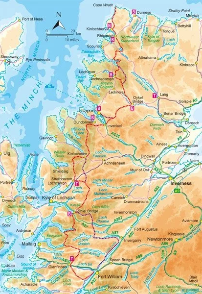
The Cape Wrath Trail has the reputation as the UK’s most challenging long distance walk. Over the years I’ve visited many places on the trail (Glenfinnan, Assynt, Inchnadamph, Strathcarron, Ullapool, Kinlochbervie abd Cape Wrath, but I’ve never walked between them all. This walk would in a sense square the circle of my Scottish Highland adventures.
The Trail is an unofficial, unmarked and magnificently wild long distance route from Fort William to Cape Wrath, the most north westerly point of mainland Scotland. A superb and challenging route for experienced long-distance backpackers, the Trail passes through some of Scotland’s most spectacular landscapes.
This 200-mile, two-to-three-week tramp up the rugged northwest edge of the Highlands whets hard-core adventurers’ appetites. Morar, Knoydart, Assynt … the nation’s most grueling trail passes places so remote, many are known simply as wildernesses—because there are no settlements worth noting within them.
Traversing such emptiness, this hike claims numerous superlatives: Britain’s remotest village, highest waterfall, remotest beach and highest mainland sea cliffs, Europe’s oldest geological formations. But while all these held allure, my main motivation for taking on this trek was absence. Roads do not peter out up here—they scarcely exist anyway. The trail is not uncrowded—it is almost utterly unpeopled. If one wished to truly escape within Great Britain, this would be it.
10. The Urban V Trail (France) – 428km
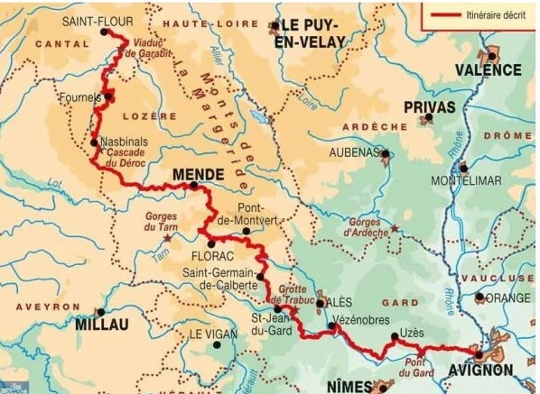
I’d originally planned to do this walk earlier this year, but due to unforeseen circumstances had to abort it after reaching Nasbinals. As it turned out it was no bad thing as the weather was fairly atrocious and I didn’t much fancy heading towards Mt Lozere in such appalling weather. But the walk is still very much on my radar screen!
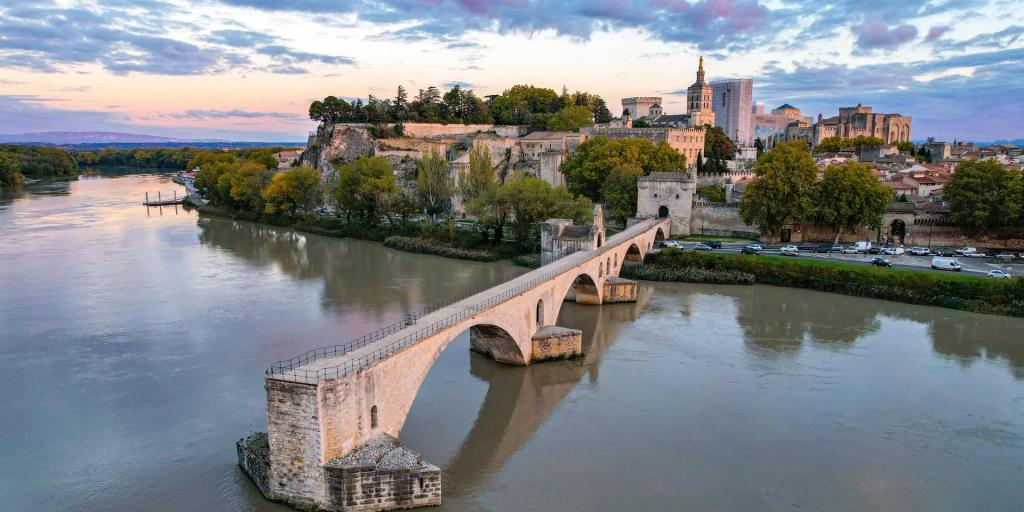
The 428km path runs from Saint Flour to Avignon, crossing the Aubrac. Mount Lozere, the Tarn gorges and the roam acqueduct at Pont du Gard before reaching Avignon.

The route follows the traces of a 14th century pope called Urban V (Guillaume de Grimouard) who was born in Grizac in the Lozere and went on to become the 12th French pope at Avignon. As a medieval historian Avignon is somewhere I’ve always wanted to visit. Besides its famous bridge, Avignon was the seat of the Popes who moved from Rome from 1309-1377. During that period they were essentially under the control of the French monarch who forced the Pope to dissolve the Knights Templar allowing the French monarchy to seize their extensive possessions and extend their power base. Be that as it may, the walk gives me as good an excuse as any to finally visit Avignon and its famous bridge.
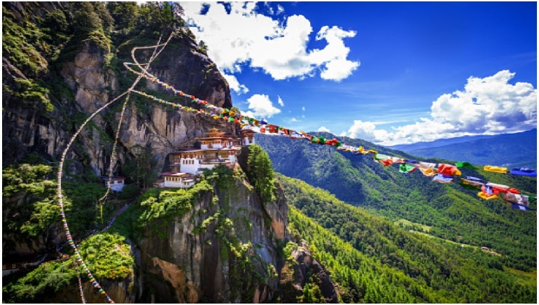
11. The Trans Bhutan Trail (Bhutan) – 430km

The 430km path, known as the footpath of the warrior monks, crosses Bhutan – somewhere I have always longed to visit.
The Trail visits 27 Gewogs, 4 Dzongs, 21 temples, 12 mountain passes, 5 suspension bridges, 10 cantilever bridges, 77 chortens and 30 stupas. It crosses a variety of terrain, from lush rice paddies, rhododendron forests, thick wilderness, remote villages and bustling towns. It also goes through some of Bhutan’s most major cities including Thimphu the capital and the royal city of Bumthang.
The Trans Bhutan Trail dates back at least to the 16th century when it connected fortresses called Dzongs and served as the pilgrimage route for Buddhists in the east travelling to the most sacred sites in western Bhutan and Tibet. Trail runners, or ‘Garps’, worked the Trail and were legendary, travelling with vital messages and mail between Dzongs at great speeds with little food or rest. The Trail came to play a major role in uniting the region’s many provinces, repelling foreign incursions, and fostering the birth of Bhutan as a nation in 1907.

By the 1960s the Trail had fallen into disuse with the construction of a national highway. Bridges, footpaths and stairways collapsed, gewogs (villages) and landholdings were separated, and this traditional pilgrimage route became neglected. It was only in 2021 after a programme to restore the ancient route that the path was re-opened to walkers.
Walking the entire trail has one downside – it isn’t cheap. The cost of visa, walking package and airfare would probably set you back something in the region of £20,000! Maybe something to look forward to on my 70th birthday!
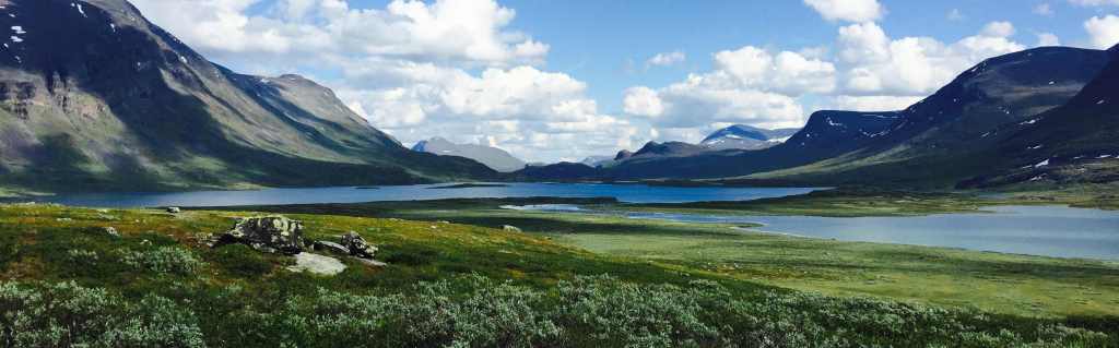
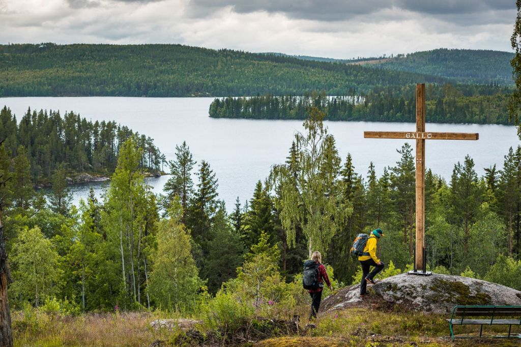
12. The King’s Way (Sweden) – 440km

Although I lived in Sweden when my father was posted there with the Foreign Office in the mid 1970s, I never did any long distance walking there. My father preferred trout fishing and doing the crossword in Swedish (which he mastered in under 6 months!) to walking.

The Kungsleden (or Kings Trail in English) is actually a hiking route of about 440 km between Abisko and Hemavan in Swedish Lapland. This trek crosses one of the least populated regions in Europe, passing through large wilderness areas but also the highest mountains (Kebnekaise (2,106m), in Sweden. The trek passes north of the Arctic Circle, which also makes it an ideal place to see the Northern Lights (finger crossed) and the midnight sun in the middle of summer.
One of the great things about walking in Sweden is the Allemansrätten, legislation which basically allows you to camp anywhere you want (even in private property) for a night (except within 100m of a house), as well as to pick berries and mushrooms to your discretion! In addition, in Sweden it is legal to light camp fires wherever you like.
The Kungsleden pases through vast amounts of uninhabited territory comprising countless waterfalls, valleys, rivers, and lakes. The walk also provides the opportunity of seeing reindeer roaming free. The Sami people (the indigenous community living in the north of Sweden and partly Norway/Finland) have traditionally herded these beautiful animals, and once a year in summer they gather them to mark them and mark the new-born. I got really lucky and managed to see a large group from very close:
You can either carry food with you or replenish your supplies en route. Staying in cabins along the trail is an option as is camping out in the wild. Other accommodation options are virtually non existent!
Walking The Kings Trail would give me a good excuse to pick up some Swedish before I go and speak it en route. Hej allihopa! Jag tror att jag är vilsen! (tr Hi everybody – I think I’m lost) As for doing the crossword in Swedish as my father did – well that might be going a step too far.
13. The Way of St Francis (Italy) – 550km

The Way of St. Francis links cultural treasures and cherished sites from the life of Francis of Assisi into a 550km pilgrimage from Florence through Assisi to Rome. Ideal for the experienced Santiago pilgrim who seeks a less crowded adventure, the route begins among the Renaissance masterpieces of Florence, continues through the forests of Tuscany, pauses to enjoy picturesque hill towns in Umbria, then concludes with a climactic arrival at St. Peter’s in Rome. Inspired by Francis of Assisi, beloved among saints, the walk allows pilgrims to experience for themselves the places he lived, prayed and worked.
The path runs through an area of Italy I’ve always wanted to visit, ever since I read Eric Newby’s “Love and War in the Appenines” a beautiful account of the author’s escape from a P.O.W. camp in Italy and the adventures which led to him being sheltered by Wanda, the lady who he later married.
14. The Greater Ridgeway (UK) – 580km
This is a walk I’ve wanted to do for many years – the long out of print Cicerone guidebook to the walk stares down reproachfully at me everyday from the bookcase in the study.. From the Jurassic Coast UNESCO World Heritage Site at Lyme Regis, through England’s varied countryside all the way to the North Sea at Hunstanton, the Greater Ridgeway is expansive and endlessly fascinating. At 362 miles (583 km) long, it’s no small undertaking but is a magnificent adventure.
In Fact the Greater Ridgeway comprises four named trails — the Wessex Ridgeway, the National Ridgeway, the Icknield Way and the Peddars Way.
The hike starts at Lyme Regis, a stunning beachside town famous for the fossils embedded into its rocks and cliffs. This is the last time you can dip your toes in the sea until you reach the finish on Norfolk’s coast and there’s something particularly special about starting and ending by the sea.
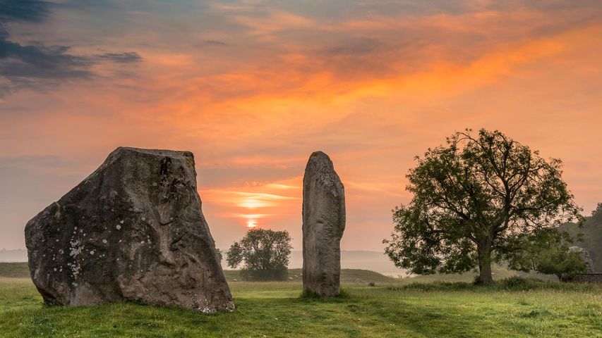
The trail heads north into Dorset’s quaint and serene countryside, passing hillfort after hillfort and working its way to Avebury’s Neolithic stone circle. You skirt the North Wessex Downs, see the prehistoric chalk horse at Uffington and wend your way into the Chilterns Area of Outstanding Natural Beauty (AONB).
This first half of the Greater Ridgeway is undulating and sometimes outright hilly, providing gorgeous views of Southern England’s vibrant pastoral landscapes, woodlands and river valleys. As you hike north, the topography levels off in Suffolk and Norfolk. Sprawling waterways, old mills and intriguing birdlife give this region a new flavour.
The final stretch, from Thetford to Hunstanton, mostly travels in a straight line thanks to following the exact route of a Roman road. Here, you find heathland, plantations, ancient burial mounds and historic towns.
Reaching Hunstanton is a huge achievement and this Victorian seaside resort is a stunning location for a finale. On the edge of the North Sea, this lovely town lies on Norfolk’s phenomenal coastline and has a sandy beach, perfect for kicking off those hiking boots and going for a paddle.
While this is a significant expedition if you choose to do the entirety in one go, the landscape itself presents no real challenges. Hilly in places, the trail sticks largely to charming rural scenes, stopping by villages and towns. History is abundant on the trail, with Iron Age hillforts, burial mounds (tumuli), ancient earthworks, castles, mills and more churches than you can shake a walking pole at, every stage brings glimpses of England’s past.
15. Saint Olaf’s Way (Norway/Sweden) – 580km
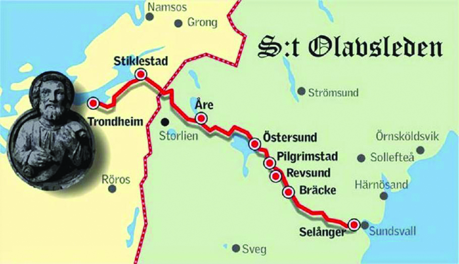
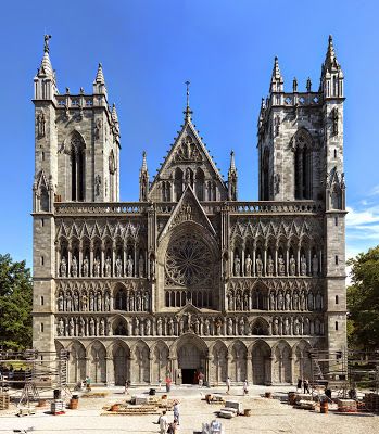
Saint Olaf’s Way is Europe’s most northerly pilgrim route. it starts in the town of Selånger, on the east coast of Sweden and ends in the Nidaros Cathedral in Trondheim, Norway. A distance of 580 kilometers from start to finish. It follows parts of the road that Olav Haraldsson traveled when he returned from Novgorod in Russia in the summer of 1030 to recapture the Norwegian throne. A journey that ended with the battle of Stiklestad, the death of Olav Haraldsson and the start of the era of St. Olav.
So who was St Olaf, why are so many Norwegians called Olaf and why is he such an important part of Norwegian identity? Born in 995AD, Olav Haraldsson was King of Norway from 1015-1028. He was canonised at Nidaros (Trondheim) a year after his death at the Battle of Stiklestad on 29 July 1030 and his remains are enshrined in Nidaros Cathedral which became a pilgrim site. His sainthood encouraged the widespread adoption of Christianity by Scandinavia’s Viking/Norsemen.
The saga of Olav Haraldsson and the legend of Olaf the Saint became central to Norway’s national identity, Saint Olaf was a symbol of Norwegian independence and pride. He is symbolised by the axe in Norway’s coast of arms and Olsok (29 July) is still his day of celebration.
There’s an interesting connection between St Olav and London! According to St. Olaf’s Saga, written several hundred years later (in about 1230), Olav was involved with Sweyn Forkbeard’s attack on London in 1017 which resulted in the English Ethelred ( aka Ethelred the Unready) pulling down London bridge to protect the city from the Viking attack. St Olav’s saga is the earliest account of the bridge’s collapse, which may have been the historical antecedent for the English nursery rhyme “London Bridge is falling down.
St Olav’s Way isn’t a particularly popular walk – only about 500 people complete it each year. That probably reflects the fact that it is pretty remote and most people who visit Norway head to its famous fjords rather than heading for the arctic circle! However, St Olav’s Way is a genuine pilgrim trail and therefore benefits from pilgrim accommodation in hostels as well as small isolated farmsteads on the trail.
The terrain is far from flat. Every day there are hills as well some fairly challenging mountain passes. The weather can also be a factor with rain, cold temperatures, muddy and swampy trails, and lots of ascending and descending being features of the walk.
16. The Slovenian Mountain Trail (Slovenia) – 620km

I’d be hard pressed to locate Slovenia on a map of Europe beyond knowing that it is somewhere in the Balkans. Beyond that all I know is that it has an impressive long distance walk through the Slovenian mountains which is not for the faint hearted.
Formed in 1991 and with a population of just 2 million, Slovenia is perhaps most famous for the majestic white horse, the Lippizaner. Oh yes, its also famous for its cyclists. The 25-year-old Slovenian rider, Tadej Pogacar, won his third Tour de France this year!
Stretching 620km, the Slovene Mountain Trail is an unparalleled hiking experience that takes you through the heart of Slovenia. The trail, inaugurated in 1953, is reputedly the oldest connecting trail in Europe. It begins in Maribor and passes through the magnificent regions of Pohorje, the Julian Alps, the Kamnik-Savinja Alps, and the Karawanks before finally ending at the Debeli Rtič on the Adriatic Sea.
The 620km trail is arguably the most challenging long-distance hike in Europe. It involves walking up more than 30 peaks crossing 55 mountain passes and staying in mountain huts along the way which means food has to be carried on the walk. To say that it is challenge would probably be a bit of an understatement!

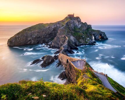
17. Camino de Santiago – Northern Way (Spain) – 800km

The author of the Codex Calixtinus, a 12th-century guide to the Camino de Santiago, didn’t think much of his walk through the Basque region. “The language spoken here is incomprehensible. The terrain is woody and mountainous with a serious shortage of bread, wine and other food supplies, except for plenty of apples and cider and milk.”
Things have changed 800 years on from the publication of the ‘world’s first travel guide’. From its tapas to its chic seaside cities, the world loves the Basque region. But the language is still incomprehensible to many, and the hilly terrain can still be a challenge.
The 800km-long Northern Way, a branch of the Camino de Santiago, runs along the most famous part of the Basque Country – its coast. Then it continues into Cantabria, Asturias and then Galicia before dropping down to the city of Santiago de Compostela.
There are many reasons why people choose to walk the Northern Way – the Camino del Norte. Famous coastal cities like Bilbao and San Sebastian are a big draw, as are lesser known ones like Guernica. Then there are scenic sandy beaches, the wind-whipped coastline, and chances to climb into the Picos de Europa mountains. Though it’s not as busy as the Camino Frances which I walked 20 years ago, it’s still very well known, well trodden and well serviced – there are signposts, cafes and services all along the route.
18 The Trans Pyrenees Way GR10 (France) – 860km
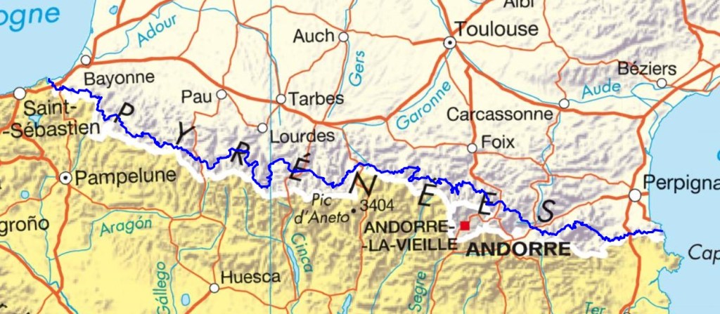
The Trans Pyrenees Way (GR10) is another iconic European long distance walk. It crosses France from one side to the other from Hendaye to Banyuls, links the Atlantic to the Mediterranean, and takes a whole range of mountains, the Pyrenees, in its stride.
The western end is lusciously green, the middle austere and rocky, but as the Mediterranean approaches, dry garrigue and blue skies take over. The walk visits all the well-known sights of the range – the Lac de Gaube, the Lac d’Ôo, the Cirque de Gavarnie – and nestles up to some of its highest mountains.
There are hostels and refuges en route but the dearth of food stores means that you often have to carry a few days food with you. Needless to say, even in the height of summer the weather in the Pyrenees can be highly unpredictable. A neighbour of mine, who is into long distance walking, claims to have walked the GR10 five or six times. Brave man. Once will be more than enough for me!
19. Via Francigena (Italy) – 990km

In 2021 I walked 1,250km of the Via Francigena from Canterbury to Bourg St Pierre, the stage just before the Great St Bernard Pass in the Alps on the Swiss/Italian border. I’d love to walk the remaining 1,000km to Rome passing through beautiful renaissance towns like Pavia, Lucca, Siena as well as the Aosta Valley and Tuscany. Of course, the cherry on the cake is reaching the eternal city, Rome, and receiving your pilgrim testimonium from the Vatican.
I’d like to take the opportunity to drop in and see Sandy Brown, the inspirational author of a number of Cicerone walking guides, including the updated guides to the Via Francigena. He lives with his wife in Lucca and suggested I pay him a visit if I ever decide to complete the Via Francigena.
The Italian section doesn’t have the same network of pilgrim hosts that was such an enjoyable feature of the French section of the Via Francigena and it is also a lot more crowded with pilgrims, particularly the section between Lucca and Siena. All that having been said, its still an iconic walk passing through beautiful Italian countryside and benefitting from ample opportunities to indulge in Italian cuisine! I reckon I should be able to complete it in a month!
20. The Czech Way (Czech Republic) – 1,058km
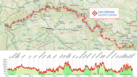
Czechia, or the Czech Republic as its otherwise known, is a walker’s paradise. There are more than 80,000 kilometers of footpaths, which is twice the circumference of the Earth.
Amongst them the Via Czechia is the longest hiking and best known hiking route. The 1,060 km long trail connects the westernmost and easternmost points of the Czech Republic and crosses some of the country’s highest mountains including Sněžka (1,603 m). The North Trail traverses 18 mountain ranges, 8 environmentally protected areas, 2 national parks and countless national nature reserves. Walkers who complete the whole trail will have climbed over 50 peaks higher than 1,000 meters and set foot on the highest, lowest, westernmost and easternmost points of the Czech Republic
There are a number of long distance paths in the Czech Republic which total over 10,000km and were established in 2019. Amongst them the North Trail is the most challenging although far less so than some of the other long distance walks in Eastern Europe such as the Slovenian Mountain Trail!
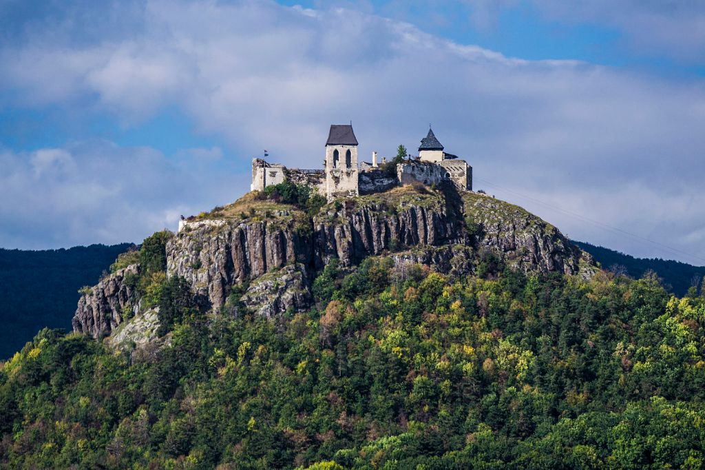
21. The National Blue Way (Hungary) – 1,130km
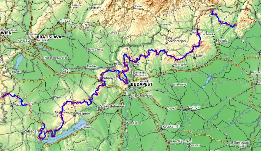
Hungary’s 700 mile/1130km National Blue Trail runs from the peak of Irottkő Mountain on the Austrian border in the west to the small village of Hollóház near the border with Slovakia in the northeast. The National Blue Trail also forms part of the E4, a European long-distance trail that runs from Portugal to Cyprus.
Situated in the lowlands of the Carpathian Basin, Hungary is mostly flat with a few mountain ranges in the north, namely the Transdanubian Mountains and North Hungarian Mountains. The highest point in the entire country and on the trail is only 3,327 feet. You won’t find dramatic peaks and steep ascents here but rather gently undulating hills and easy terrain. This makes the National Blue Trail not as strenuous as such renowned long-distance hikes like the Pacific Crest Trail or the Appalachian Trail. The low altitude and moderate difficulty make it accessible to almost anyone with a reasonable level of fitness.
The trail takes walkers on a rewarding adventure through Hungary and gives them an opportunity to visit its varied terrain and unique sights- vast deciduous forests, historic villages, rolling hills, thermal lakes, , extensive vineyards, Lake Balaton, several national parks, the capital city time in Budapest, ancient castles, and ruined fortresses. Phew, that is quite a list!
22. The Via Dinarica (Slovenia/Albania) – 1,262km
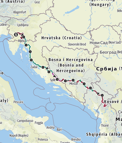
The Via Dinarica is a 1,300km long distance hiking trail which crosses the Dinaric Alps in the western Balkans. It starts in the woods and caves of Slovenia, skirts Croatia’s coastline and mountains, runs through the vast plains and mountain ranges of Bosnia and Herzegovina, winds across Montenegro’s peaks and canyons before it finishes up in northern Albania’s rugged mountains and valleys
The Dinaric Alps are named after Mount Dinara, a peak of 1,831m in the center of the mountain range on the border of Croatia and Bosnia and Herzegovina. It’s highest mountain is Maja Jezercë with a height of 2.694m in northern Albania. Both peaks are part of the Via Dinarica. Albania is apparently the new Croatia. I’ll believe that when I see it.
23. Via Transilvanica (Romania) – 1,400km
There is more to Romania than Count Dracula! By European standards, Romania is a pretty huge place (roughly the same size as the UK, in fact). But it’s also a country of mind-boggling contrasts. Ranging from Transylvanian castles and monasteries to huge mountain ranges, vast forests and culture-packed cities, Romania is an enormous – and enormously beautiful – country.
And now a lot of that stuff is spanned by a single, 1,400km-long hiking trail. It’s called the Via Dinarica, and it runs all the way from Putna, a northern town near the Ukrainian border, to Drobeta-Turnu Severin on the Danube, and the country’s south-western border with Serbia. En route it passes medieval monasteries, as well as the historic “Land of the Szeklers”. Here, people live from and with nature, breed the ancient Hutsul horses, make medicine from plants, build traditional instruments, and care for the region’s wild animals.
Further south, the Via Transilvanica continues through Transylvania, legendary home to Dracula, Vlad Țepeș. The region is a nature lovers paradise known for its unique biodiversity, and is home to over 600 species of butterflies. The trail ends at the impressive Danube Delta.
And as for Count Dracula, we ll nowadays walkers are less at risk from meeting him than encountering brown bears which still roam the mountain ranges of Romania!
24. The Wales Coastal Path (UK) – 1,400km

The Wales coastal path is 870 miles (1,400 km) in length and follows the coast from the mouth of the River Dee, along the northern coast of Wales with its seaside towns such as Conwy, over the Menai Strait onto the Isle of Anglesey, past Caernarfon, and then around the Lleyn Peninsula and down the sweep of Cardigan Bay past Harlech, Aberystwyth, and Cardigan, through the Pembrokeshire Coast National Park to Tenby, around the Gower Peninsula to Swansea, along the waterfront of Cardiff Bay and Cardiff, to Chepstow.
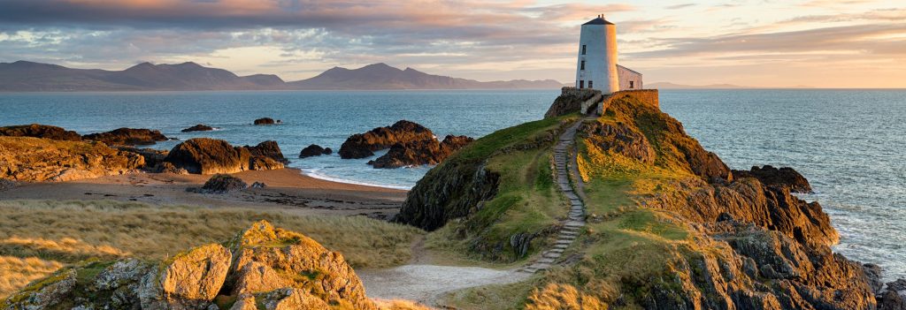
That makes the Wales coastal path considerably longer than the South West Coastal Path (630 miles). Although I walked sections of the Pembrokeshire coastal path with Olivia in 2013, there are an awful lot of places on the Welsh coast that I’d like to visit including Anglesey and Caernarvon. And it would be fun to revisit Barmouth – the last time I was there was on a scouts camp during the drought of 1976!
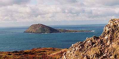
Walking the Wales Coastal Path would also give me the opportunity to visit Bardsey Island (also known as the island of 20,000 Saints), a centre of pilgrimage for hundreds of years which lies 2 miles off the Lleyn peninsula and is also the end point of the North Wales Pilgrim’s Way..
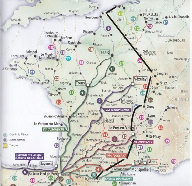
25. Via Turonensis GR655 (France) 1,500km
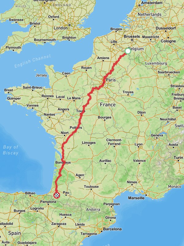
The Way of Tours, or the Via Turonensis, is the most northerly of the four medieval French pilgrim routes described by Aimery Picaud in the Pilgrim’s Guide, and the one used by pilgrims from France, Northern Europe, and the British Isles. Also known as the Via Turonensis after Tours, the most important medieval city along the route.
The path stretches 1,500km from Brussels to the Pyrenees passing through Paris from where is goes to Orléans,then follows the Loire valley to Tours where it joins the route from Chartres; it then goes southwest through Poitou and the Saintonge to Bordeaux; and finally passes through les Landes to join the routes from Le Puy and Vézelay at Gibraltar just beyond Saint-Palais. The medieval route would have been along Roman roads and the main towns were all major Roman towns at important cross-roads, many already major pilgrimage centres in their own right.
The terrain is fairly flat but one of the main advantages of the walk is that it benefits from a network of pilgrim host families who provide an evening meal, a bed for the night and breakfast to pilgrims, all for the princely sum of 20-30 euros.
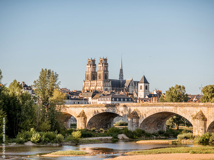
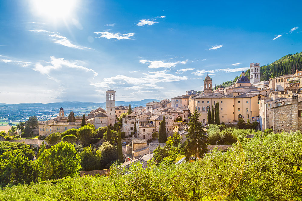
26. The Way of Assisi (France/Italy) 1,500km
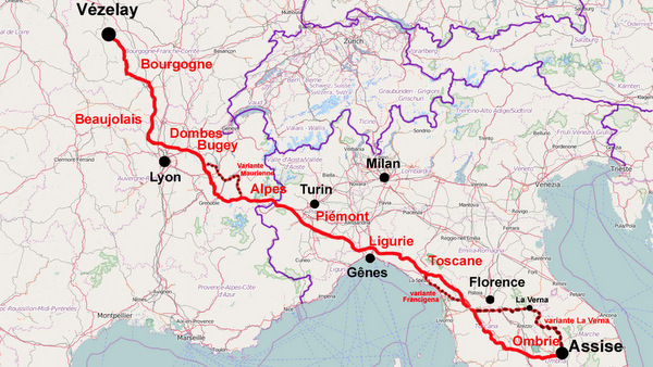
Not to be confused with the Way of St Francis which runs 550km between Florence and Rome in the footsteps of St Francis of Assisi, the Way of Assisi runs 1,500km from Vezelay to Assisi. The walk passes through Morvan, Beaujolais, Dombes and the valley of Maurienne before crossing the Alps into Italy via the Mount Cenis Pass. It then passes through Piedmont, Lombardy to the heights of La Spezia before crossing Tuscany and Umbria and reaching Assisi. Around 650km of the walk is in France and 850km in Italy.
The route was only created a few years ago so it still fairly unknown. Nevertheless it does benefit from a network of pilgrim host families who provide accommodation for pilgrims en route.
27. The Customs Officers Path (France) 2,000km
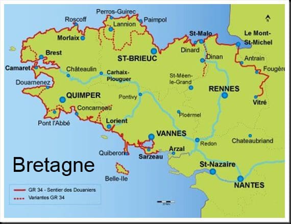
The Customs Officers Path (GR34) is the most popular long distance path in France, stretching 2,000km along the Brittany coastline from Mont St Michel to the bridge of St Nazaire.
Created in 1791, the path was travelled by controls of customs officers – hence its name – in charge of preventing smuggling. To keep an eye on trafficking and on the pillaging of shipwrecks, they strode up and down the coastline, night and day, in all weather: think of this when your legs are tired! After falling into disuse in the early 20th century, the path experienced a revival in 1968, when a few passionate walkers decided to make it into a walking route. The famous white and red markers that signpost the route first appeared near Lannion: the GR® 34 was born!

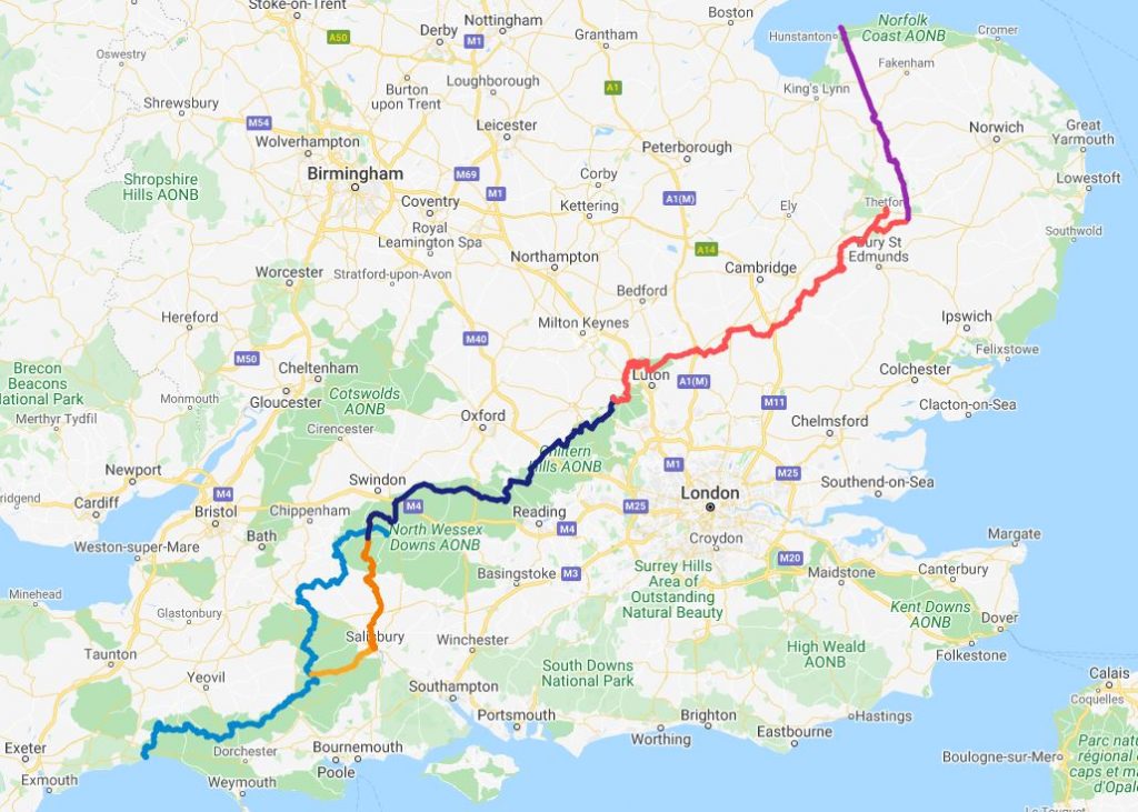
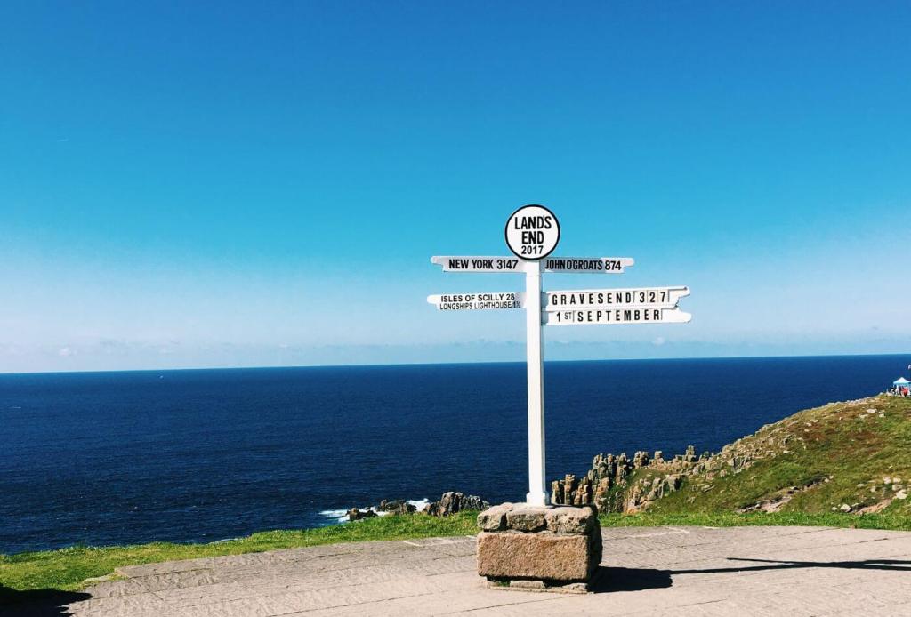
28. Lands End to John O’Groats (UK) – 2,000km
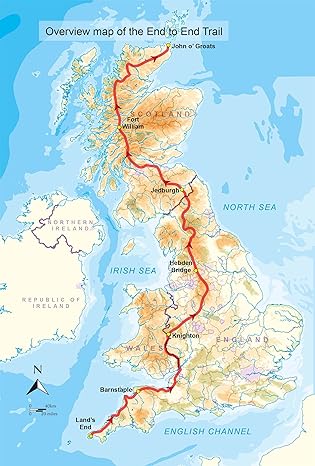
The 2,000km walk from Lands End to John O’Groats (LEJOG) has to be on every British long distance walker’s bucket list. If I was to walk LEJOG I would follow the route shown above as described in Andy Robinson’s End to End guide. I’d aim to complete the walk in 61 days including 4 rest days and averaging 21 miles a day. I’d aim to travel light and stay in accommodation every night rather than wild camping.
I’ve dreamt of walking it since 1980 when I first read John Hillaby’s epic account of his walk across Britain. I hoped to complete the walk this year but logistics meant I had to shelve the idea. I can come up with all sorts of reasons not to do the walk (cost, difficulty, time needed) but I can’t escape the fact that I’d still love to complete the walk at some stage in my life. And of all the walks on my bucket list, if there was just one that I could walk, it would be LEJOG!
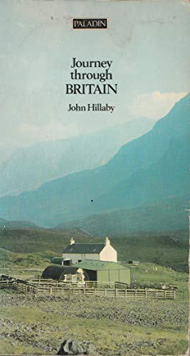
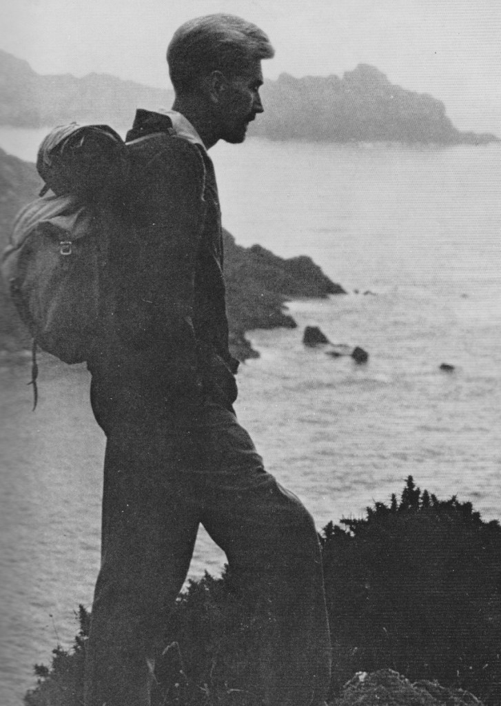
When he set out to walk from Land’s End to John OGroats in 1968, John Hillaby was by no means the first to do the walk. What made his walk different to his predecessors was that he decided to avoid all roads and turn the walk into a beautiful and inspiring experience. He was the first to make the walk into a shared experience. In doing so he was probably responsible for inspiring hundreds of walkers (including me) to follow in his footsteps and undertake the challenge of completing LEJOG.
Hillaby summed up beautifully why walking from Land’s End to John O’Groats remains such an iconic walk for long distance walkers such as myself: “For me the question wasn’t whether it could be done, but whether I could do it. I’m fifty. I’m interested in biology and pre-history. They are, in fact, my business. For years I’ve had the notion of getting the feel of the whole country in one brisk walk: mountains and moorlands, downloads and dales. Thick as it is with history and scenic contrast, Britain is just small enough enough to be walked across in the springtime. It seemed an attractive idea. There was a challenge in the prospect.”
29. Northernmost to Southernmost Traverse (France) – 2,000km
There is no official footpath between the most northerly (Bray-Dunes on the Belgian border) and most southerly (Lamanere on the Spanish border) points of France. I’ve only discovered two people who have ever walked the route so it’s obviously a lot less popular than LEJOG (Lands End to John O’Groats) which thousands of people have completed over the years, in the process raising hundreds of thousands of pounds for charity.
As the crow flies, the distance between the two most northerly and southerly points of France is around 1,000km. If I was to walk it, the distance would be nearer 2,000km as I would try and stick to pilgrim routes and avail myself of pilgrim host family accommodation. A back of the envelope calculation suggests the walk would take me around 2 months – pretty much identical to the time I would target completing LEJOG.
From Bray-Dunes I would head along the Channel coast to Calais and join the Via Francigena as far as Langres where I would head south to Dijon and Le Puy and then follow the GR7, GR787, GR78 and GR36 to the Pyrenees. And if I completed it I could claim to be the first Englishman to have done so. Now there’s a thought!

30. Hook of Holland to Nice GR5 (France) – 2,200km
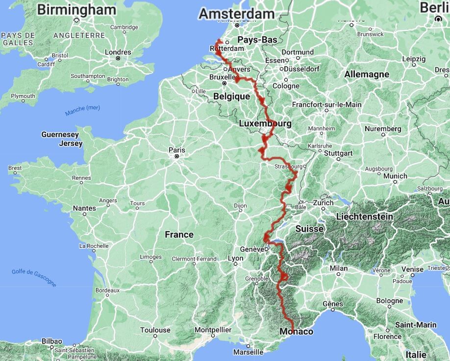
The GR5 is a long distance footpath that runs from the North Sea at Hoek van Holland in the Netherlands down to the Mediterranean at Nice in France. The trail covers some 2.200 kilometers (1.500 miles) and wanders through Holland, Belgium, and Luxembourg before turning south in France to climb into the Alps, tracing the borders with Switzerland and Italy. This final section through the Alps from Lake Geneva down to the Mediterranean takes about five weeks to complete and is considered among the greatest long walks in all of Europe. As far as I can ascertain, few people ever get to walk the entire GR5. I did come across a group of Dutch women who completed the walk but it took them something like 20 years!
John Hillaby walked much of this route in 1969 and described his walk in his travelogue ‘Journey through Europe’. Much has changed in the last 50 years but the route remains as challenging as ever. Hilllaby completed the entire walk in a little under 2 months – pretty good going for somebody lugging a 30 pound backpack!
I have to confess that there were a few other long distance walks I toyed with including on this bucket list but then decided to reject. These include a 4,500km walk around South Korea (Korea Dulle Trail) – it takes 6 months to complete and accommodation options are limited! The 2,500km Sultan’s Trail from Vienna to Istanbul pretty much follows the route Paddy Leigh-Fermor walked in the 1930s. However, waymarking is non existent, its incredibly lonely and it involves a lot of walking along busy roads.
I also looked into walking 4,500km along the entire length of the Great Wall of China – it’s already been done in 2006 by Katie-Jane L’Herpiniere a 26 year catwalk model from Devon with no prior walking experience other than treading the boards of the catwalk! She followed this feat up by cycling the 1911 original Tour de France (5,439km), in 23 days! (https://youtu.be/dEGvuHeZzLs)
How realistic is it to contemplate completing all 30 walks that are on my bucket list? At first glance it appears just a pipe dream. The 30 walks total a little over 26,000km. If I were to walk 1,500km a year, as I did this year, then I’d theoretically be able to complete all 30 walks in 16-17 years. There’s a thought!
In life you never know what is around the corner but you can always dream! And if I ever complete my bucket list of long distance walks, what then? Well what about the longest walk on earth?

In 2019, reddit user cbz3000 played around on Google Maps to find the longest route that you could walk without having to cross an ocean. Stretching 22,387km, it runs from Cape Town, South Africa to Magadan, Russia.
It crosses 16 countries: South Africa, Botswana, Zimbabwe, Zambia, Tanzania, Uganda, South Sudan, Sudan, Georgia, Egypt, Jordan, Syria, Turkey, Romania, Belarus, and Russia.
The route ascends a total of 117,693m and descends 117,686m –- the equivalent of 13 Mount Everests. Google estimates that it takes 4,492 hours (187 days) to walk the entire distance, but in Google’s infinite wisdom, this is 24 hours a day, no breaks! More reasonably, if you walked eight hours a day, the walk would take 562 days to complete, not including rest days.
In the 1970s, Dave Kunst became the first person to walk completely around the earth. It took him four years. Steven Newman was the first to walk solo around the world. Fyona Campbell walked for 11 years across America, Africa and Europe, and Rosie Swale Pope ran around the world in 2003. The idea of walking across the world is not new, but this route is.
Perhaps the reason that this has never been attempted is the risk that accompanies it. The route is littered with visa restrictions, war-torn regions, civil wars, and unstable governments. Besides politics, anyone who attempted it would need exceptional skills to tackle the constantly changing terrain and temperatures.
Maybe Tom Fremantle is up for the challenge and will need some company if he decides to take it on As Lord Albemarle says about Phileas Fogg in Jules Vernes’ ‘Around the World in 80 Days’ – “If the thing is feasible, the first to do it ought to be an Englishman“.

Leave a reply to annaisobeltattersallgmailcom Cancel reply